
Vermont Map
|
 |
 |
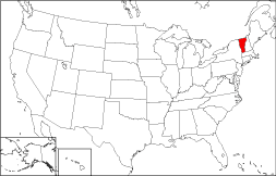
Where Is Vermont?
On the map to the right, you can see that the State of Vermont is bounded by the Canadian Province of Quebec on the north and by Massachusetts on the south. Vermont is also bordered by New Hampshire on the east and by New York State on the west.
Vermont Maps
Vermont is the 43rd largest state in the United States, covering a land area of 9,250 square miles (23,958 square kilometers). The state consists of 14 counties. This Vermont map site features road maps, topographical maps, and relief maps of Vermont. The detailed, scrollable road map displays Vermont counties, cities, and towns as well as Interstate, U.S., and Vermont state highways. The pannable, scalable Vermont street map can be zoomed in to show local streets and detailed imagery.
Vermont Highway Map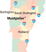 Click on the highway map thumbnail
to view a scalable Vermont road map. |
VT Topo Map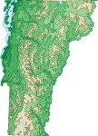 Click map to enlarge.
|
VT Relief Map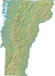 Click map to enlarge.
|
The detailed Vermont map and the regional Vermont map display cities, roads, rivers, and lakes as well as terrain features. The detailed map shows only the State of Vermont, while the regional map shows Vermont and the surrounding region.
Vermont Infrastructure > Vermont Airports
In 2005, the population of Vermont was estimated at 622,387, which is about 67.4 people per square mile. In 2010, Vermont's population rose to 625,741 people. More recently, in the 2020 census, the Vermont population was 643,077. The state's Interstate Highways include I-89 and I-91. The only major Vermont airport is the Burlington International Airport in South Burlington.
Vermont Topography and Attractions
Vermont is derived from the French phrase "vert mont", which means "green mountain". The Green Mountains range from north to south, and dominate the state's terrain. Lake Champlain separates the state from New York, forming most of Vermont's western border. The Connecticut River runs along the state's eastern border with New Hampshire. Vermont's ski slopes, such as Stowe and Killington, are popular with winter sports enthusiasts, while history buffs enjoy the Bennington Museum or Billings Farm. The magnificent setting of Vermont's Trapp Family Lodge reminds visitors of the story behind the Sound of Music.
For Vermont travel and tourism information, visit the official Vermont tourism site and Vermont Atlas.
Other Maps of Vermont
This Vermont reference map shows major cities, roads, railroads, and physical features in Vermont.Several map publishing companies offer printed maps of Vermont. For example, Omni Resources offers several maps of Vermont that feature points of interest, airports, and parks, as well as selected local attractions and insets of major Vermont cities.
All rights reserved.
Certain maps hereon are © Map Resources or Digital Wisdom.
To facilitate browsing, certain external links will open in new windows.
Vermont-Map.org Editor, State Maps, PO Box 828, Barnegat, NJ 08005.